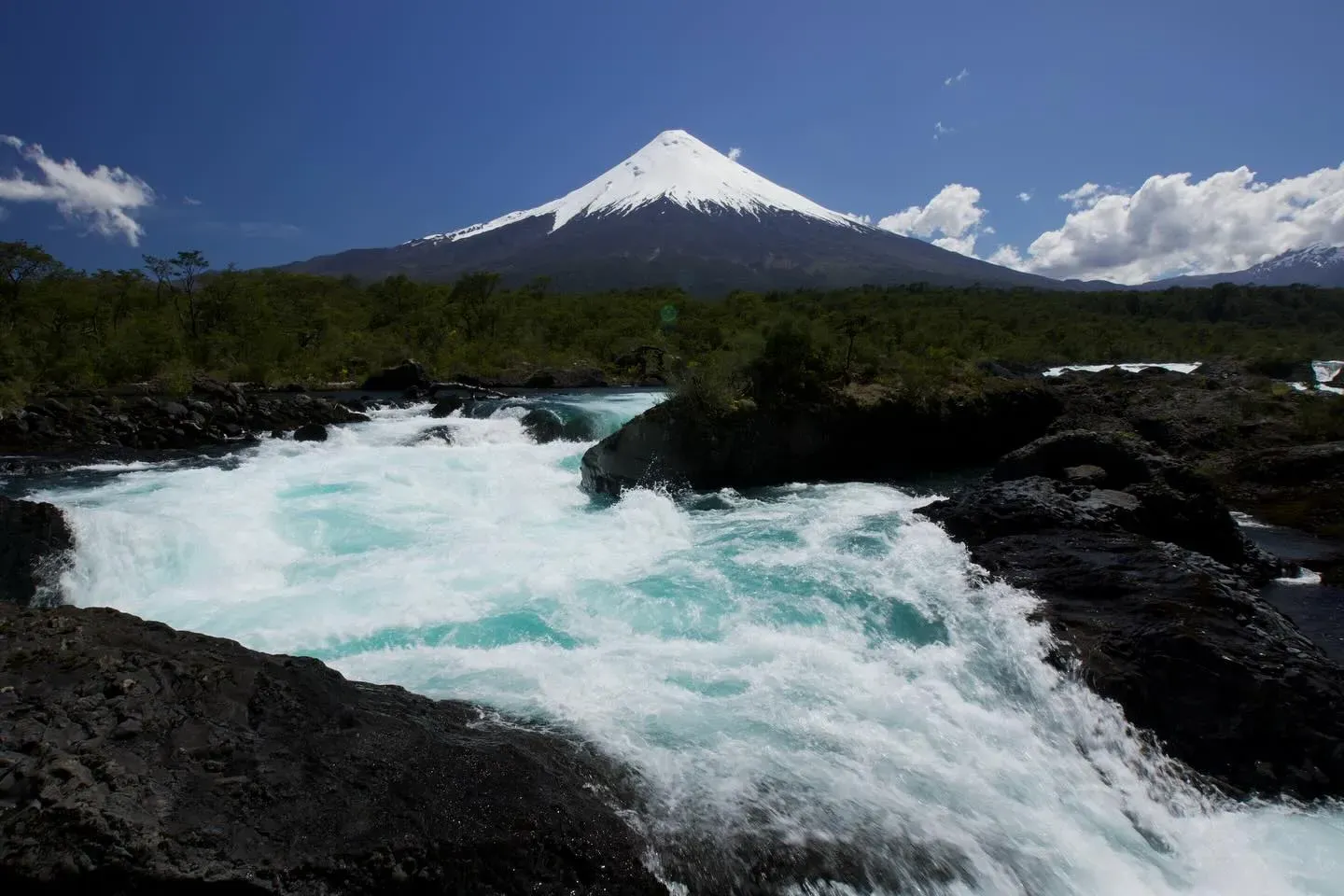
Petrohue Waterfalls push 270 cubic meters of turquoise water per second through narrow basaltic lava channels in southern Chile. The site anchors Vicente Pérez Rosales National Park, sitting directly beneath the 2,652-meter Osorno Volcano.
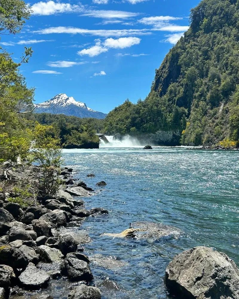
Petrohue Waterfalls force 270 cubic meters of turquoise water per second through narrow basaltic lava channels. The site sits 55 kilometers east of Puerto Varas, anchoring Chile's oldest protected area, Vicente Pérez Rosales National Park. Glacial meltwater from Lake Todos los Santos violently drops 190 meters above sea level into a gorge carved from ancient andesite lava. The 2,652-meter snow-capped cone of the Osorno Volcano dominates the skyline directly behind the rapids. Heavy mist rises from the impact zones. Constant moisture coats the surrounding Valdivian temperate rainforest.
Visitors walk along elevated wooden boardwalks suspended directly over the surging channels. The roar of the water drowns out conversation at the main observation decks. Dark, polished basalt formations contrast sharply with the bright blue river. During the peak summer months of January and February, large biting flies called tábanos swarm the area. These insects aggressively target dark clothing and ignore standard chemical repellents. Travelers arriving before 10:00 AM avoid both the insects and the massive tour groups arriving from coastal cruise ships. A typical visit lasts 1.5 to 2 hours.
The site requires a 7,000 CLP entry ticket for adult foreigners. Purchasing passes online via the official pasesparques.cl portal prevents delays, as mobile cell service drops completely near the entrance gates. Ramps and wide platforms allow wheelchairs and strollers to reach the primary viewpoints safely. Local buses labeled 'Petrohué' depart from the corner of San Bernardo and Walker Martínez in Puerto Varas every 30 minutes, costing 3,000 CLP for the 80-minute ride. Private taxis charge around 25,000 CLP for the same route. Visitors should bring Chilean Pesos in cash, as card machines in this rural area frequently fail. Mudslides, known locally as lahars, occasionally sever the paved Route 225 during periods of intense rainfall.
Eruptions from the Osorno Volcano laid the foundation for the waterfalls thousands of years ago. Massive flows of basaltic andesite lava poured into the valley, completely filling the original riverbed. The Petrohué River eventually found a new path over this hardened volcanic rock. Abrasive volcanic sand and glacial silt carried by the current acted like liquid sandpaper against the stone. Centuries of this constant friction sculpted the jagged lava into the smooth, undulating chutes visible today. The water continues to cut deeper into the basalt with each passing year.
The Chilean government recognized the ecological value of the surrounding watershed in the early 20th century. Officials established Vicente Pérez Rosales National Park on August 17, 1926. This designation protected 2,530 square kilometers of Valdivian rainforest, lakes, and volcanic peaks. Early infrastructure consisted of rough dirt paths carved through dense vegetation. Access remained difficult for decades. Only determined explorers and local indigenous communities who navigated the lower river reached the falls during this era.
Paving Route 225 transformed the site from a remote outpost into a major regional destination. The national forestry corporation, CONAF, installed elevated wooden boardwalks and steel railings to protect both tourists and the fragile volcanic rock. Heavy rains and occasional volcanic activity continually reshape the landscape. Lahars—destructive mudflows triggered by heavy precipitation mixing with volcanic ash—periodically wash out access roads. The water itself changes color from its signature turquoise to a murky brown after these geological events. Park authorities strictly enforce rules against drones and off-trail hiking to mitigate human impact on the delicate gorge ecosystem.
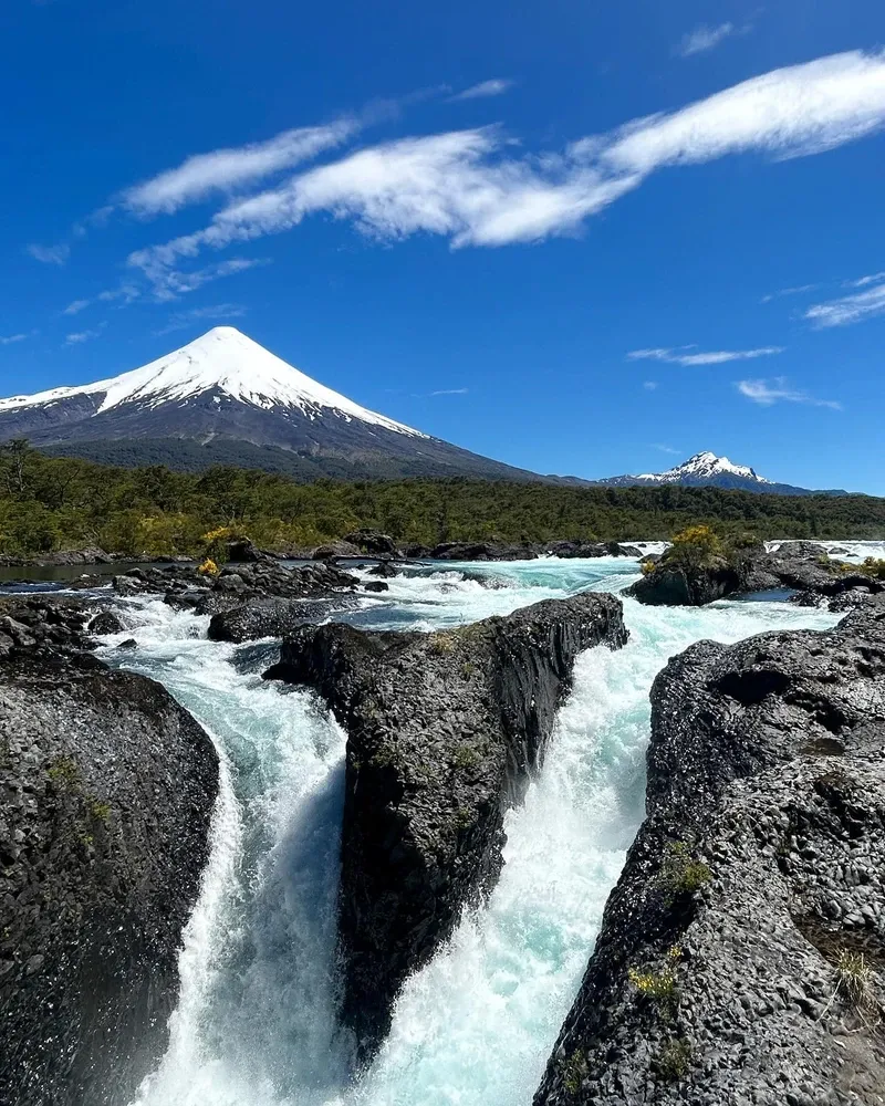
Dark, polished basaltic andesite forms the structural core of the Petrohué Waterfalls. The river pushes its massive volume through narrow, asymmetrical chutes rather than dropping over a single vertical cliff. This immense pressure creates intense rapids that churn with white foam before settling into deep, turquoise pools. The rock surfaces exhibit a glassy smoothness. Deep circular depressions, known as potholes, dot the riverbed where trapped stones spun in whirlpools for centuries.
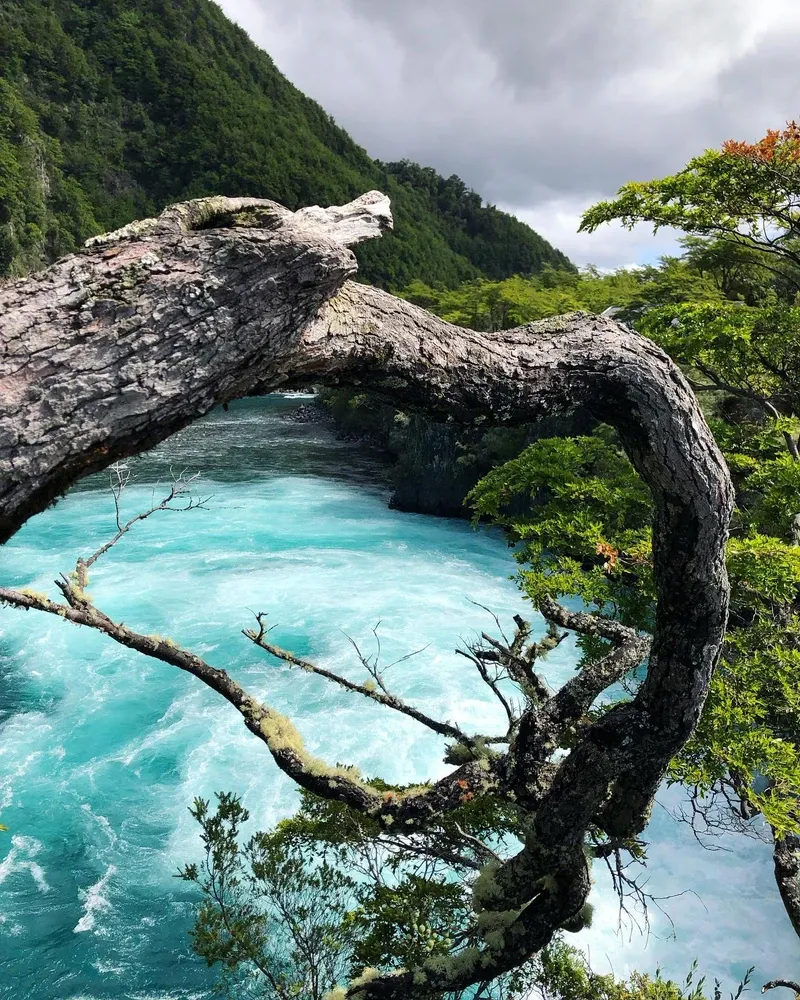
Beyond the main boardwalks, the 'Los Enamorados' trail offers a quieter, downstream perspective of the Petrohué River. This path moves away from the primary rapids, revealing how the water slows and widens after exiting the basalt gorge. The water originates six kilometers upstream at Lake Todos los Santos, which sits at an elevation of 189 meters. Glacial meltwater feeds the lake, giving the river its distinct blue-green hue. During the rainy season, the lake level rises by up to three meters. This drastically increases the volume and violence of the falls. Dense stands of coigüe and ulmo trees lean over the gorge, their roots anchoring into thin layers of soil on top of the lava. The environment receives 4,000 millimeters of rain annually, keeping the mosses and ferns perpetually damp.
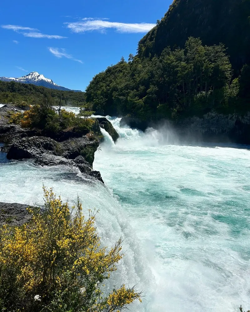
The Carilemu Trail provides a 980-meter walking loop through this ecosystem. Fenced observation decks project directly over the most turbulent sections of the main chute. Visitors standing on these platforms feel the physical vibration of the water hitting the basalt. The spray completely coats the lower viewing areas during high-flow months. Native Torrent Ducks frequently navigate the lower rapids, diving into currents that would easily crush a human swimmer.
The Petrohué River watershed holds deep historical roots for the Mapuche-Huilliche people. The river formed a natural boundary and a challenging navigation route between the Andes and the Pacific coast. The name 'Petrohué' translates roughly to 'place of mosquitoes' or 'place of dampness' in the indigenous Mapudungun language. This accurately reflects the dense, wet conditions of the Valdivian rainforest and the seasonal insect swarms. Local communities historically respected the falls as a site of immense, unpredictable natural power.
The falls function as the primary symbol of Chile's Lake District. The visual contrast of the bright blue water against the black volcanic rock and the symmetrical white cone of Osorno Volcano dominates regional tourism campaigns. The site anchors the local economy of nearby Ensenada, a village located 15 minutes away by car. Residents rely on the steady influx of visitors for craft sales, guiding services, and transportation. Many travelers combine the falls with a 30-minute boat ride on Lake Todos los Santos or a drive up to the Osorno Volcano Ski Center. Strict national laws, including Law No. 20,653, protect the area by prohibiting fires and unauthorized drone flights. Violators face immediate expulsion from the country, reflecting Chile's modern commitment to preserving its oldest protected landscape.
The water flow averages 270 cubic meters per second, creating immense pressure through the narrow channels.
The smooth rocks are made of basaltic andesite lava from ancient eruptions of the Osorno Volcano.
Native Torrent Ducks routinely swim and dive in the violent rapids without being swept away.
The biting flies known as 'tábanos' are highly attracted to dark clothing during January and February.
The surrounding Valdivian rainforest receives an average of 4,000 millimeters of precipitation every year.
Swimming is strictly prohibited due to the extreme undercurrents and jagged underwater rock formations.
Heavy rains can trigger 'lahars'—mudslides of volcanic ash that occasionally turn the turquoise water completely brown.
Yes, tickets are available at the gate. However, purchasing them online at pasesparques.cl prevents waiting in long queues during the peak summer season.
No direct bus exists from Puerto Montt. Travelers must take a 20-minute bus to Puerto Varas, then transfer to a Petrohué-bound micro.
Yes. Large flies called tábanos swarm the area in January and February. They aggressively target dark clothing and movement.
Usually, the glacial meltwater maintains a bright blue-green color. Heavy rains or volcanic mudslides can temporarily turn the river brown with silt.
Yes. The main viewing platforms and the 980-meter Carilemu trail feature ramps and wide wooden boardwalks designed for wheelchairs.
No. Park authorities strictly prohibit swimming. The lethal currents and hidden volcanic rock formations make the water extremely dangerous.
Yes. A paid parking lot operates at the visitor center for 500 CLP. Do not leave valuables visible inside your vehicle, as break-ins occasionally occur.
The visitor center contains a small café and souvenir shop. Full meals require a 15-minute drive back to the village of Ensenada.
No guide is necessary. The park features self-guided trails with educational signage in multiple languages.
The gates open 365 days a year. Operating hours drop slightly during Christmas and New Year's Day.
Browse verified tours with free cancellation and instant confirmation.
Find Tours